Recently this data was shared in Parliament by the Ministry of Environment, Forest and Climate Change.
According to the data, a quarter of India’s geographical area (24.49 %) is under forest and tree cover.
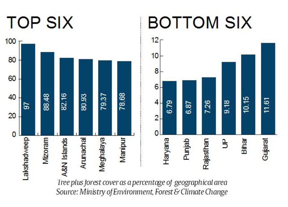
Northeast crowds the list of states with most dense tree, forest cover.
Manipur, Arunachal Pradesh, Mizoram and Meghalaya are among the top 6 states with highest forest and tree cover.
The lowest forest and tree cover is in Haryana at 6.79 % of its geographical area. Punjab follows with 6.87 %.
Top 3 States with maximum Forest cover (in terms of area):
Madhya Pradesh (77,414 sq km)
Arunachal Pradesh (66,964 sq km) and
Chhattisgarh (55,547 sq).
Top states with highest Forest cover in terms of percentage geographical area:
Lakshadweep with (90.33%),
Mizoram (86.27%) and
Andaman & Nicobar Islands (81.73%)
Rajasthan’s forest and tree cover is over 7.26% of its geographical area while Madhya Pradesh’s is 27.73 %.
Top 5 States with maximum increase in forest cover,
Andhra Pradesh (2141 sq km),
Karnataka (1101 sq km)
Kerala (1043 sq km),
Odisha (885 sq kms) and
Telangana (565 sq kms)
Goa and Kerala are two other states with more than 50 per cent of their geographical area under forest and tree cover.
Forest Survey of India (FSI) has been assessing the forest and tree resources of our country on a biennial basis since 1987.
The results of the assessment are published in its biennial report titled “India State of Forest Report (ISFR)”.
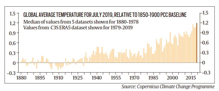
July 2019 was the hottest ever month
July 2019 was the hottest ever month on record, announced by World Meteorological Organization (WMO)
It was based on a new report from the European Union's Copernicus Climate Change Programme.
July 2019 was close to 1.2°C above the pre-industrial level and 2019 has already logged several record-hot months.
The month was characterized by relentless heat waves around the world.
On July, numerous European countries including Belgium, Germany and the Netherlands experienced new national heat records with temperatures in excess of 104 degrees Fahrenheit.
This year brought several severe heat waves to Europe, India, and Pakistan.
The previous hottest month, July 2016, occurred during one of the strongest El Niños ever.
The extraordinary heat was accompanied by dramatic ice melt in Greenland, in the Arctic and on European glaciers.
The ice sheets of Greenland alone lost a staggering 217 billion tons of ice last month.
It is enough to raise global average sea levels by 0.02 inches (0.5 millimeters).
Meanwhile, unprecedented wildfires scorched so much of the Arctic, releasing about 100 megatons of carbon dioxide into the atmosphere
The planet was already warmed up by about 1.8 F (1 C) above pre-industrial levels and are poised to hit the 2.7-degree threshold as soon as 2030.
Floods in Krishna river
Krishna river, the lifeline of south-western Maharashtra, has wreaked havoc in the districts it flows through.
Large tracts of land in Satara, Sangli, Kolhapur and Pune continue to remain under water.
Dams dot the course of Krishna and her tributaries across Maharashtra, Karnataka, Andhra Pradesh and Telangana.
These dams are the lifeline of western Maharashtra, and are a major supporting factor for the area’s sugarcane-based economy.
Almatti, a major dam on Krishna, located in Karnataka, close to the Maharashtra border, controls the flow of water into the neighbouring state.
The position of Almatti dam is unique, as this is the first dam on Krishna river after it leaves Maharashtra.
The amount released from the dam is important to prevent any flooding upstream of Krishna, which is Maharashtra.
Poor dam management, where the dam gates were opened suddenly, and the catchment areas were flooded.
Dam management is an inter-departmental job.
It involves close coordination between the departments of revenue, water resources and agriculture and the weather forecaster.
The release of water is managed by taking into account the projected water usage for human consumption, agriculture and industries.
In case of a weak monsoon, less water is released to tide over the non-monsoon months.
Krishna river
Krishna River or Krishnaveni is one of the longest rivers in Peninsular India.
It is the fourth largest river in India after the Ganga, Godavari and the Narmadha.
It rises at Mahabaleswar in district Satara, Maharashtra and flows through Maharastra, Andhra Pradesh and Karnataka.
The delta of this river is one of the most fertile regions in India.
It was the home to ancient Satavahana and Ikshvaku Sun Dynasty kings.
Vijayawada is the largest city on the River Krishna.
The principal tributaries joining Krishna are the Ghataprabha, Malaprabha, Bhima, Tungabhadra and Musi River.
‘Polavaram’ right bank canal connects Godavari River to the Krishna river.
‘Agumbe’ which receives second highest rainfall (7,620 mm mean annual) in India, is located in the Krishna river basin.
‘Krishna Wildlife Sanctuary’ which harbors vast tracts of pristine mangrove forests is located here.
The basin has a rich mineral deposits such as oil &gas, coal, iron, limestone, dolomite, gold, granite, laterite, uranium.