0.1510
900 319 0030
x

Prelim Bits 14-05-2023 & 15-05-2023 | UPSC Daily Current Affairs

iasparliament Logo
May 15, 2023

Palghat Gap

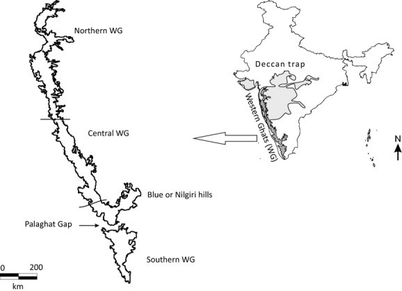
The Palghat Gap is a significant discontinuity in the Western Ghats, which has unique features from the rest of Western Ghats.

  • The Palghat Gap is a significant discontinuity in the Western Ghats of about 40 km wide.
  • The steep Nilgiris and Anamalai hills both rising above 2,000 MSL, on either side of the Palghat gap.
  • The Gap is a geological shear zone that runs from east to west.
  • Shear zones are weak regions in the earth’s crust.

palghat 

  • Origin - After Australia and Africa broke off from the Gondwana landmass, India and Madagascar remained as one landmass.
  • A large-scale volcanic activity split the two and the split occurred where the Palghat Gap is located.
  • This is mirrored in the Ranotsara Gap on the eastern face of Madagascar.
  • The landmass split about 100 million years ago, and the Gap had formed long before this.
  • Significance - The Palghat Gap has historically been important as a significant gateway into the State of Kerala.
  • It is a corridor for both roads and railways that connects Coimbatore with Palakkad.
  • The Bharathappuzha River flows through the Palghat Gap.
  • Distinct differences - The vegetation in the Palghat Gap is classified as dry evergreen forest whereas the Western Ghats is a tropical rainforest.
  • The Western Ghats in north of the Palghat Gap receive more rain annually, but the south gets rain more evenly throughout the year.
  • The gap also marks a divide in the flora and fauna of the region.
  • For example: several species of frogs are found only on one side of the Gap.
  • Elephant populations on the Nilgiris side differ in their mitochondrial DNA from elephants in the Anamalai and the Periyar sanctuaries.
  • The Blue robin found around Ooty and Baba Budan are called the Nilgiri blue robin and the Anamalai group is called the White-bellied blue robin.
  • Biodiversity - The species richness and phylogenetic diversity of the biodiversity of the region of Western Ghats south of the Palghat Gap are abundant.

Species richness is the number of species present in the community, while phylogenetic diversity is the summed evolutionary age of all the species in the community.

References

  1. The Hindu - A break in the Western Ghats

Cyclone Mocha

The cyclone Mocha is the strongest cyclone on earth so far in this year.

  • Cyclone Mocha, which formed over the southeast Bay of Bengal, intensified into a very severe cyclonic storm.
  • It made landfall on the Myanmar coast near Sittwe and Cox’s Bazar (Bangladesh).
  • The India Meteorological Department (IMD) categorised Cycloe Mocha as an ‘Extremely Severe Cyclonic Storm’.
  • Mocha became the strongest cyclone ever recorded in the North Indian Ocean, including for all seasons and in both Arabian Sea and Bay of Bengal, since 1982.
  • It also became the strongest cyclone in the North Indian Ocean during the pre-monsoon season, tying with Cyclone Fani.
  • It did not undergo ‘stalling’, but brought heavy rainfall over the north Myanmar-southeast Bangladesh coasts.

‘Stalling’ is a phenomenon where a cyclone sustains on a water body, gaining moisture for a longer time before entering the land.

  • Tropical Cyclone - Tropical cyclones are intense circular storm that originates over warm tropical oceans.
  • It is characterized by low atmospheric pressure, high winds, and heavy rain.
  • It draws its energy from the sea surface and maintaining its strength as long as it remains over warm water.
  • These strong winds are accompanied by torrential rains and storm surge.
  • It can elevate of the sea surface by 6 metres (20 feet) above normal levels.
  • Such a combination of high winds and water makes cyclones a serious hazard for tropical and subtropical coastal areas.
  • It can occur over the late summer months (July–September in the Northern Hemisphere and January–March in the Southern Hemisphere).
  • Tropical cyclones are known by various names in different parts of the world.
Name Area
Hurricanes The North Atlantic Ocean and the eastern North Pacific
Typhoons The western North Pacific around the Philippines, Japan, and China
Tropical cyclones or cyclones The western South Pacific and Indian Ocean

References

  1. DTE - Mocha is the strongest cyclone on earth so far in this year

Gharial in Pakistan

A gharial (Gavialis gangeticus) has been seen in Pakistan’s Punjab province for the first time after three decades.

  • Gharials had become extinct years ago in the Punjab region of both India and Pakistan.
  • Gharials were reintroduced to the Beas River in 2017, in the Punjab region now divided between India and Pakistan
  • Between 2017 and 2021, some 94 gharials were released into the Beas River to bring back the species to its rivers.
  • The animals were brought mostly from the Chambal basin in Madhya Pradesh
  • The gharials found in the Pakistan’s Punjab is possibly moved from India during floods last year and stayed there in the Sutlej River.
  • Gharials - Gharials are fish-eating fresh water crocodiles characterised by narrow and bulbous nasal snout.
  • Habitat - Gharials live in clear freshwater river systems and are a good indicator of clean river water.
  • Distribution - Gharial were historically found in the river system of India, Pakistan, Bangladesh and southern part of Bhutan and Nepal.
  • The surviving population can be found within the tributaries of the Ganges river system.
  • Girwa (Uttar Pradesh), Son (Madhya Pradesh), Ramganga (Uttarakhand), Gandak (Bihar), Chambal (Uttar Pradesh, Madhya Pradesh and Rajasthan) and Mahanadi (Orissa).
  • The largest and most populous location, the protected National Chambal Sanctuary.
  • Diet - They are largely piscivorous (eats fish).
  • Threats - Dams and Barrages, irrigation, sand mining, illegal fishing and bycatch of young ones.
  • Conservation Status -

Protection

Status

Wild Life (Protection) Act, 1972

Schedule I

IUCN

Critically Endangered

CITES

Appendix I

References

  1. DTE - Gharial seen in Pakistan’s Punjab after 3 decades
  2. WWF India - Gharials

Petermann Glacier, Greenland

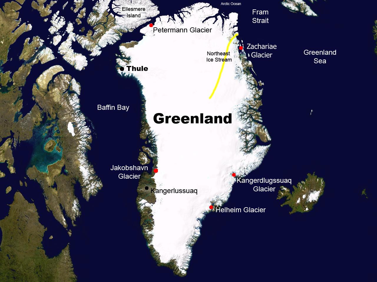
Glaciologists have found the grounding line of Petermann Glacier in northwest Greenland to shift substantially during tidal cycles.

  • Grounding line of a glacier is where the ice detaches from the land bed and begins floating in the ocean.
  • The shifting of grounding line substantially during tidal cycles, allows warm seawater to intrude and melt ice at an accelerated rate.
  • Exposure to ocean water causes the ice to slide more quickly to the sea in two ways -
    • Melts the ice vigorously at the glacier front.
    • Erodes resistance to the movement of glaciers over the ground.
  • Petermann Glacier - It is located on the northwestern coast of Greenland.
  • It covers 1,295 square kilometers and is 15–20 kilometers wide and 70 kilometers long.
  • It is the longest floating glacier in the Northern Hemisphere.
  • In 2010 and in 2012, large pieces of the Petermann glacier broke off its end and floated out to sea.
  • Petermann Glacier's grounding line retreated nearly 4 kilometers between 2016 and 2022.
  • The warm water carved a 200-metre-tall cavity in the underside of the glacier, and that abscess remained there for all of 2022.
  • These ice-ocean interactions make the glaciers more sensitive to ocean warming.

greenland_glacier

References

  1. The Hindu - Grounding line of Greenland's glacier
  2. EROS: U.S. Geological Survey - Petermann Glacier, Greenland

Green hydrogen bunks by 2035

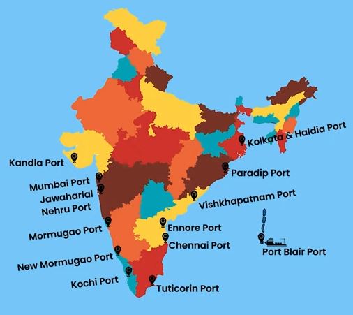
The government said green hydrogen bunkering and refuelling facilities shall be established at all major ports by 2035.

  • The Ministry of Ports, Shipping and Waterways (MoPSW) launched green port guidelines, ‘HaritSagar’.
  • The guidelines, ‘HaritSagar   ’ is a part of efforts to achieve zero carbon emission goal.
  • The guidelines said that green ammonia bunkers and refuelling facilities shall be established at all Major Ports by 2035.
  • Under this, all ports will make efforts to achieve the target of renewable energy as envisaged in Maritime India Vision (MIV) 2030/Blue Economy 2047 documents.

Maritime India Vision (MIV) 2030, the roadmap prepared by MoPSW for the maritime sector in the country, aims to strengthen the maritime sector through concerted interventions.

  • Targets - Share of renewable energy at Ports should exceed 60% by the Year 2030 and 90% by year 2047.
  • The ports has to set up at least one LNG bunkering station by 2030 and e-vehicle charging stations in and around port areas by 2025.
  • Bunkering - Bunkering operation is a procedure for transferring oil, sludge or cargo to and from a ship.
  • Three of India’s 12 major ports would initially have bunker facilities for green hydrogen and ammonia.
  • The initial ports in the effort are to be Paradip in the east, Kandla in the west, and Tuticorin in the south.
  • Related Topic - Green Tug Transition Programme

https://www.iasparliament.com/uploads/files/ports.JPG

India’s Ports

  • India’s coastline stretches 7,500 km (4,660 miles).
  • It has more than 200 ports in addition to the 12 major ones.
  • These ports all together accounts for 95% of its trade by volume and 65% by value.
  • 12 major ports - Deendayal (Kandla), Mumbai, Mormugao, New Mangalore, Cochin, Chennai, Ennore (Kamarajar), Tuticorin (VOC), Visakhapatnam, Paradip and Kolkata (including Haldia) and Jawaharlal Nehru Port.

References

  1. The Hindu - Green hydrogen bunkering, refuelling facilities by 2035
  2. IE - Green hydrogen bunkering at major ports by 2035
Login or Register to Post Comments
There are no reviews yet. Be the first one to review.

ARCHIVES

MONTH/YEARWISE ARCHIVES

Free UPSC Interview Guidance Programme