0.1535
900 319 0030
x

IFLOWS-Mumbai - Integrated Flood Warning System

iasparliament Logo
June 13, 2020

Why in news?

Maharashtra’s CM and Union Minister for Health and Family Welfare, Science and Technology recently launched an Integrated Flood Warning System called ‘IFLOWS-Mumbai’.

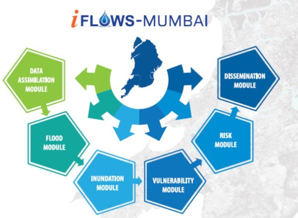
What is ‘IFLOWS-Mumbai’?

  • IFLOWS is a joint initiative between the Ministry of Earth Sciences (MoES) and Brihanmumbai Municipal Corporation (BMC).
  • It is a monitoring and flood warning system.
  • It will be able to relay alerts of possible flood-prone areas anywhere between 6 to 72 hours in advance.
  • The system can provide all information regarding possible flood-prone areas including -
    1. the height the floodwater could attain
    2. location-wise problem areas across all 24 wards
    3. calculation on the vulnerability and risk of elements exposed to flood
  • The early warning forecast would include alerts on -
    1. rainfall information
    2. tide levels
    3. storm surge for low-lying areas anticipated to be affected
  • The system is designed to generate flood warnings for specific geographical areas of the city.
  • All this information will then be routed to authorities.
  • It thereby will minimize the damage from cyclones and heavy rain events in Mumbai by evacuating people to safe areas.

How does it work?

  • The primary source for the system's flood assessments is the amount of rainfall.
  • However, Mumbai being a coastal city, the system also factors in tidal waves and storm tides.
  • In the last 2 years, researchers have been conducting studies to provide real-time weather information.
  • This is being done by measuring -
    1. the city’s rainfall, how much water drained out
    2. topography, land use, infrastructure development
    3. population
    4. lakes, creeks
    5. data on river bathymetry of all rivers namely Mithi, Dahisar, Oshiwara, Poisar and Ulhas
  • The system incorporates -
    1. weather models from the National Centre for Medium Range Weather Forecasting (NCMRWF), India Meteorological Department (IMD)
    2. field data from the rain gauge network of 165 stations set up by Indian Institute of Tropical Meteorology (IITM), BMC and IMD
  • The system has provisions to capture the urban drainage within the city and predict the areas of flooding.
  • It comprises of various modules namely Data Assimilation, Flood, Inundation, Vulnerability, Risk, Dissemination and Decision Support System.

What is the need?

  • Mumbai, the financial capital of India, has been experiencing floods with increased periodicity.
  • The flood during 26 July 2005, when the city received a rainfall of 94 cm, a 100-year high in a span of 24 hours had paralyzed the city completely.
  • The flood on 29 August 2017 had brought the city to a standstill.
  • In 2019, there were post-monsoon and unseasonal rainfall as late as October and two tropical cyclones in the Arabian Sea.
  • These have left a trail of destruction in Mumbai.
  • Urban flooding is common in the city from June to September, resulting in the crippling of traffic, railways and airlines.
  • As preparedness for floods before they occur, the IFLOWS-Mumbai system will help in warning the citizens.
  • Mumbai is only the second city in the country after Chennai to get this system.
  • Similar systems are being developed for Bengaluru and Kolkata.


Source: Indian Express

Login or Register to Post Comments
There are no reviews yet. Be the first one to review.

ARCHIVES

MONTH/YEARWISE ARCHIVES

Free UPSC Interview Guidance Programme