0.1550
900 319 0030
x

Prelim Bits 01-04-2024 | UPSC Daily Current Affairs

iasparliament Logo
April 01, 2024

UNESCO Global Geoparks Network

UNESCO’s Executive Board has endorsed the addition of 18 sites to the UNESCO Global Geoparks network.

  • Geoparks – UNESCO Global Geoparks are areas with internationally important rocks and landscapes, all of which are managed responsibly for conservation, education and sustainable development.
  • With Geology at its foundation, UNESCO Global Geoparks build upon by bringing together other aspects of heritage such as archaeology, history, culture and biodiversity.

Global Geoparks Network (GGN)

  • In 2004, 17 European and 8 Chinese geoparks came together at UNESCO headquarters in Paris to form the Global Geoparks Network (GGN).
  • The Global Geoparks Network was founded under the umbrella of UNESCO.
  • Headquarters – Paris
  • During the 38th session of UNESCO’s General Conference in 2015, the 195 Member States of UNESCO ratified the creation of a new label, the UNESCO Global Geoparks.
  • The GGN is a dynamic network where members work together to share examples of good practice and join together in common projects.
  • The Geopark tag is akin to that of a ‘World Heritage Site’ for historical monuments that can bring famed geological features to the global stage.
  • India – India is a signatory to the establishment of UNESCO Global Geoparks.
  • However, it does not have any legislation and policy for conservation of geoheritages.
  • Geological Survey of India (GSI) identifies sites as National Geological Monuments.
    • Geological Survey of India is an attached office to the Ministry of Mines with its headquarters at Kolkata.
  • India is one of those countries which do not have a single geopark registered and acknowledged under UNESCO Global Geopark list.

A stone deity (Kakad Bhairav or Bhilat Baba) worshipped by the Bhils in Madhya Pradesh’s Bagh was proved to be a fossilized dinosaur egg. With this discovery, India hopes to get its first UNESCO Global Geopark Tag.

Newly added GGNs

Geopark

Country/ Region

Schelde Delta Geopark

Belgium & Netherlands

Uberaba Geopark

Brazil

Enshi Grand Canyon-Tenglongdong Cave

China

Linxia Geopark

China

Longyan Geopark

China

Mount Changbaishan Geopark

China

Wugongshan Geopark

China

Xingyi Geopark

China

Biokovo-Inotski Lakes Geopark

Croatia

South Fyn Archipelago Geopark

Denmark

Impact Crater Lake – Lappajarvi Geopark

Finland

Armorique Geopark

France

Normandie-Maine Geopark

France

Meteora Pyli Geopark

Greece

Bukk Region Geopark

Hungary

Land of Extinct Volcanoes Geopark

Poland

Oeste Geopark

Portugal

Calatrava Volcanoes Geopark

Spain

The addition of 18 new sites brings the total number of Geoparks to 213 across 48 countries and all of these countries are members of the Global Geoparks Network (GGN).

Quick Facts

UNESCO

  • UNESCO is the United Nations Educational, Scientific and Cultural Organization.
  • It contributes to peace and security by promoting international cooperation in education, sciences, culture, communication and information.
  • UNESCO promotes knowledge sharing and the free flow of ideas to accelerate mutual understanding and a more perfect knowledge of each other's lives.
  • UNESCO's programmes contribute to the achievement of the Sustainable Development Goals defined in the 2030 Agenda, adopted by the UN General Assembly in 2015.

References

  1. UNESCO – UNESCO names 18 new Geoparks
  2. Global Geoparks Network – Global Geoparks Network (GGN)
  3. UN News – UNESCO names 18 new Geoparks

Katchatheevu Island

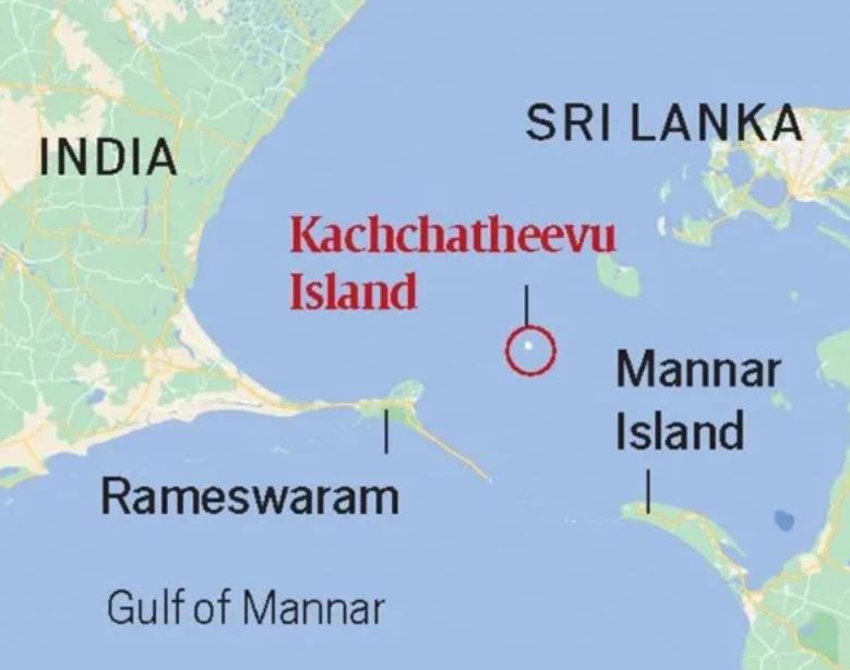
Prime Minister blamed the congress for giving away the island of Katchatheevu.

  • Location – Being the product of a 14-century volcanic eruption, Katchatheevu is relatively new in the geological timescale.
  • Katchatheevu is a 285-acre uninhabited speck (a very small spot) in the Palk Strait, between India and Sri Lanka.
  • It is no more than 1.6 km in length and slightly over 300 m wide at its broadest point.
  • It lies northeast of Rameswaram, about 33 km from the Indian coast.
  • It is about 62 km southwest of Jaffna, at the northern tip of Sri Lanka, and 24 km away from the inhabited Delft Island, belonging to Sri Lanka.
  • Church – The only structure on the island is an early 20th-century Catholic shrine, St Anthony’s church.
  • During an annual festival, Christian priests from both India and Sri Lanka conduct the service, with devotees from both India and Sri Lanka making the pilgrimage.

Katchatheevu is not suited for permanent settlement as there is no source of drinking water on the island.

  • Dispute – Katchatheevu was controlled by the Jaffna Kingdom of Sri Lanka.
  • In the 17th century, control passed to the Ramnad zamindari based out of Ramanathapuram, about 55 km northwest of Rameswaram.
  • It became part of the Madras Presidency during the British Raj.
  • However, in 1921, both India and Sri Lanka, at the time British colonies, claimed Katchatheevu in order to determine fishing boundaries.
  • A survey marked Katchatheevu in Sri Lanka, but a British delegation from India challenged this, citing ownership of the island by the Ramnad kingdom.
  • This dispute was not settled until 1974.
  • Maritime Agreement – In 1974, Indira Gandhi made attempts to settle the maritime border between India and Sri Lanka, once and for all.
  • As a part of this settlement, known as the ‘Indo-Sri Lankan Maritime agreement’, Indira Gandhi ‘ceded’ Katchatheevu to Sri Lanka.
  • As per the agreement, Indian fishermen were still allowed to access Katchatheevu hitherto.
  • Unfortunately, the issue of fishing rights was not ironed out by the agreement.
  • Sri Lanka interpreted Indian fishermens’ right to access Katchatheevu to be limited to rest, drying nets and for visit to the Catholic shrine without visa.

Another agreement in 1976, during the period of Emergency in India, barred either country from fishing in the other’s Exclusive Economic Zone. Again, Katchatheevu lay right at the edge of the EEZs of either country, retaining a degree of uncertainty with regards to fishing rights.

References

  1. The Indian Express – Katchatheevu Island
  2. The Hindustan Times – Katchatheevu Island issue
  3. India Today – Katchatheevu Island row

Empathetic Voice Interface (EVI)

Hume, a New York-based research lab and technology company, has introduced what can be called the ‘first conversational AI with emotional intelligence’.

  • EVI is an Application Programming Interface (API) is powered by its proprietary empathic large language model (eLLM).
  • This eLLM reportedly understands and emulates tones of voices, and word emphasis to optimise human-AI conversations.
  • The most standout featured of EVI is its integration capability, rather than being just a solitary application.
  • Applications –
    1. AI assistants who can converse in a humanlike manner.
    2. Customer support agents who can provide a more natural and relatable service.
    3. Therapists adept at comprehending a wide range of human emotions and thoughts.

DALL-E

  • DALL-E is a software that lets users generate art with the help of artificial intelligence.
  • DALL-E has its origin in GPT (Generative Pre-trained Transformer).
  • This is an open-source artificial intelligence program that can translate text, answer questions, summarize passages and generate new text.
  • DALL-E is an implementation of GPT that essentially swaps text for pixels.
  • DALL-E is a transformer language model that was trained on a large number of images and accompanying captions.
  • This allows it to create original images from scratch using just text description.
  • It can combine different objects, concepts, characteristics and styles while creating an image.

Sora

  • Sora is OpenAI’s text-to-video generative AI model.
  • Similar to ChatGPT, one enters a text prompt, but instead of generating answers to questions or prompts in text form, Sora will generate videos up to one minute long.

References

  1. The Indian Express – EVI, AI with emotional intelligence
  2. The Economic Times – Hume’s EVI with emotional intelligence
  3. The Indian Express – DALL-E

Konda Reddi Tribes

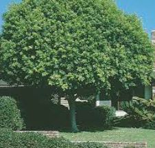
Konda Reddi tribe’s indigenous knowledge of Indian laurel tree proves resourceful.

  • Location – Konda Reddis are inhabiting on the banks situated on either side of river Godavari in the hilly and forest tracts of East and West Godavari and Khammam districts of Andhra Pradesh.
  • Konda Reddis are recognized as Primitive Tribal Group.
  • Konda Reddis are categorized as particularly vulnerable tribal group (PVTG).
  • The population of Konda Reddis as per 1991 Census is 76,391.
  • Language – The mother tongue of Konda Reddis is Telugu.
  • Social structure – The Konda Reddi family is patriarchal and patrilocal.
  • Monogamy is a rule but polygamous families are also found.
  • God – They worship Muthayalamma (Village deity), Bhumi Devi (Earth Goddess), Gangamma Devi (River Goddess) etc.
  • Festival – They celebrate festivals like Mamidi Kotha, Bhudevi Panduga, Gangamma Panduga and Vana Devudu Panduga.
  • DanceThe men and women folk jointly perform the traditional colourful dance viz., Bison horn on festive and marriage occasions.
  • Political Organisation – Konda Reddies have their own institution of social control called ‘Kula Panchayat’.
  • Each village has a traditional headman called ‘Pedda Kapu’.
  • Livelihood – They are primarily shifting cultivators and largely depend on flora and fauna of forest for their livelihood.

Quick Facts

Indian Laurel Tree

  • Range – Southeast Asia, India, Sri Lanka.
  • Introduced as an ornamental tree for gardens.
  • It did not become invasive until the 1980's when the pollinating wasp was accidentally introduced.
  • The Indian Laurel is in the Fig Family, and produces a fig-like fruit that contains about 150 seeds.
  • A single large tree may produce 100,000 fruit.
  • Indian Laurels are also known as ‘strangling figs’ because they are often seen growing on other trees and seriously threaten their host’s survival.
  • Indian Laurel seedlings can sprout almost anywhere that a seed lands.

References

  1. The Hindu – Konda Reddi’s indigenous knowledge on Indian laurel
  2. India Today – Video shows water gushing out of laurel tree in Andhra
  3. Government of Bermuda – Indian Laurel

Central Water Commission (CWC), Central Groundwater Board (CGWB), Central Ground Water Authority (CGWA)

There is only enough water to fill 23% of the holding capacity in all of South India’s reservoirs, Central Water Commission data.

Central Water Commission (CWC)

  • CWC was earlier known as Central Waterways, Irrigation and Navigation Commission (CWINC).
  • It was established in 1945 by the Government on the advice of Dr. B.R. Ambedkar, Member in Viceroy’s Executive Council.
  • The organization currently functions as an office attached to the Ministry of Jal Shakti, under the Department of Water Resources, River Development, and Ganga Rejuvenation.
  • The work of the Commission is divided among 3 wings namely:
    1. Designs and Research (D&R) Wing
    2. River Management (RM) Wing
    3. Water Planning and Projects (WP&P) Wing
  • Role – Initiate and Coordinate the schemes introduced by the Ministry of Jal Shakti.
  • Functions –
    1. Technical Appraisal of Irrigation Projects.
    2. Management and Control of Floods.
    3. Checking Financial Feasibility and Economic Viability of Different Irrigation Projects.

Central Groundwater Board (CGWB)

  • Central Ground Water Board (CGWB) is the National Apex Agency, a subordinate office of the Ministry of Water Resources, Government of India.
  • It is entrusted with the responsibilities of providing scientific inputs for management, exploration, monitoring, assessment, augmentation and regulation of ground water resources of the country.
  • Central Ground Water Board was established in 1970 by renaming the Exploratory Tube wells Organization under the Ministry of Agriculture, Government of India.
  • It was merged with the Ground Water Wing of the Geological Survey of India during 1972.
  • Central Ground Water Board is a multi-disciplinary scientific organization consisting of Hydrogeologists, Geophysicists, Chemists, Hydrologists, Hydro meteorologists and Engineers.
  • Headquarters – Haryana.

Central Ground Water Authority (CGWA)

  • Central Ground Water Authority has been constituted under Section 3 (3) of the Environment (Protection) Act, 1986.
  • CGWA aims to regulate and control development and management of ground water resources in the country.
  • Activities –
    1. Macro/micro level groundwater management studies.
    2. Exploratory drilling programme.
    3. Monitoring of groundwater levels and water quality through.
    4. Implementation of demonstrative schemes for artificial recharge and rainwater harvesting for recharge augmentation.

References

  1. The Hindu – Impact of a summertime water crisis
  2. CWC – About
  3. CGWB – About
  4. CGWA – About


Other Important News

Ritonavir

California-based Varda Space Industries made an HIV drug, Ritonavir in space.

  • It is a protease inhibitor drug used for the treatment of Human Immunodeficiency Virus (HIV) / Acquired Immuno Deficiency Syndrome (AIDS).
  • Ritonavir is not a cure for HIV infection and it is always used in combination with other HIV medicines.
  • Ritonavir (given at low doses) is currently used as a pharmacokinetic enhancer to boost the activity of other HIV medicines.

Antiretroviral Therapy (ART)

  • On April 1, 2004, the Indian government had launched Free Antiretroviral Therapy (ART), for Persons living with HIV (PLHIV).

HIV (human immunodeficiency virus)

  • HIV is a virus that attacks the body’s immune system. If HIV is not treated, it can lead to AIDS (acquired immunodeficiency syndrome).
  • There is currently no effective cure. Once people get HIV, they have it for life.

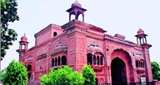
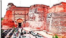
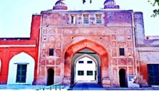
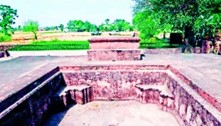
Historical Places in News (Punjab)

Places

Importance

Ram Bagh Gate

  • Ram Bagh Gate was built around 200 years ago near Ram Bagh Chowk built during the reign of Maharaja Ranjit Singh.
  • It has been listed in UNESCO Asia-Pacific Awards for Cultural Heritage Conservation in 2023.

Ram Bagh Gate

Bathinda Fort

  • Bathinda Fort, popularly known as Quila Mubarak was constructed by Raja Dab during 90-110 AD to stop the invasion of Emperor of Kanishka by Huns.

Bathinda Fort

Ranjit Singh Fort

  • Maharaja Ranjit Singh Fort, also known as Phillaur Fort, was originally built by Shah Jahan.
  • In 1809, Maharaja Ranjit Singh rebuilt it as a fort with the help of his French and Italian generals.

Ranjit Singh Fort

Takht-i-Akbari

  • It is the coronation platform of Mughal emperor Jalal-ud-din Mohammad Akbar.

Takht-i-Akbari

Zoonotic diseases

Diseases

Definition

Severe acute respiratory syndrome coronavirus (SARS-CoV-1)

  • It is a viral respiratory disease caused by a SARS-associated coronavirus.
  • It is an airborne virus and can spread through small droplets of saliva in a similar way to the cold and influenza.

Severe acute respiratory syndrome coronavirus (SARS-CoV-2)

  • SARS-CoV-2 is a member of a large family of viruses called coronaviruses.
  • These viruses can infect people and some animals.

Nipah

  • NiV is a member of the family Paramyxoviridae, genus Henipavirus.
  • Fatality rate - 75% of cases.
  • Animal host - fruit bats infected animals (such as pigs).

Hendra

  • Hendra virus is a member of the Paramyxoviridae family, genus Henipavirus.
  • Fatality rate – 75%.
  • Animal host - Fruit bats (flying foxes) to horses, and then horses can pass the infection on to humans

Ebola


  • Ebola virus disease (EVD or Ebola) is a rare but severe illness in humans. Fatality rate - 50%
  • Animal Host - fruit bats, chimpanzees, gorillas, monkeys, forest antelope, or porcupines.

Swell waves

Swell waves inundated coastal areas in central and southern districts of Kerala recently.

  • About - A swell is a group of waves (usually with smooth, unbroken tops) traveling across the ocean, created and energized by storm winds raging hundreds or thousands of miles out to sea.
  • The swell has a distinguishable collective height, period, and direction.
  • Direction - It moves from very deep water away from its source, such as a hurricane or other storm event towards very shallow water near the coast.
  • The size and quality of these waves will depend on the local winds, tide, and surf break.

International Network for Terrestrial Research and Monitoring in the Arctic (INTERACT)

  • It is a project funded by the European Union that gives researchers access to research stations in the Arctic, northern alpine regions, and forests in Europe, Russia, and North America.
  • The network offers researchers the chance to work in remote areas that are often difficult to access.
  • In exchange, new researchers provide input that leads to cross-fertilization, comparative measurements, and new research directions at the individual infrastructures.

Saffir-Simpson (SS) hurricane wind scale

  • The Saffir-Simpson (SS) hurricane wind scale is the most widely used metric for warning the public about the dangers of tropical cyclones introduced in 1970.
  • The SS hurricane wind scales are categorised by the maximum sustained wind speed at a height of 10 metres.
  • Categories

74-95 mph

Very dangerous winds will produce some damage

96-110 mph

Extremely dangerous winds will cause extensive damage

111-129 mph

Devastating damage will occur

130-156 mph

Catastrophic damage will occur

157 mph or higher

Catastrophic damage will occur

  • This scale does not take into account other potentially deadly hazards such as storm surge, rainfall flooding, and tornadoes.

Chamayavilakku (traditional lamp)

  • Chamayavilakku, also known as the Kottankulangara Festival, is a Hindu festival in Kerala to honor the goddess Bhagavathy.
  • During the festival, men dressed as women take out processions with lamps in their hands.
  • The men hold the divine Chamayavilakku (traditional lamp) and walk around the temple as a symbol of their devotion.
  • Boys below the age of 10 also dress like girls and participate in what is called Kakkavilakku that is held during day time.

Market borrowings

A recent ICRA report says that Tamil Nadu emerges top borrower in 2024 for the 4th successive year.

  • The market borrowing of a government refers to the amount of money the government borrows from the financial markets to finance its budget deficit or to fund specific projects.
  • This borrowing can take the form of issuing government bonds or treasury bills.
  • These securities can be issued by both the center and the state governments. State governments participate in market borrowing by issuing State Development Loans (SDLs).
  • The tenor of these securities ranges from 5 years to 30 years.

Daniel Kahneman

Daniel Kahneman was died recently at the age of 90.

  • Kahneman was an Israeli-American psychologist who led a groundbreaking behavioral science research changed the understanding of how people think and make decisions.
  • He is a corecipient of the Nobel Priz
Login or Register to Post Comments
There are no reviews yet. Be the first one to review.

ARCHIVES

MONTH/YEARWISE ARCHIVES

Free UPSC Interview Guidance Programme