0.1749
900 319 0030
x

UPSC Daily Current Affairs | Prelim Bits 10-05-2020

iasparliament Logo
May 10, 2020

Military Engineering Service

  • MES is an Inter Service Organization but has both Army and Civilian component of officers and other subordinate staff.
  • While execution of all construction works is through contracts, execution of all maintenance services are both through contracts as well as departmentally employed labour (DEL).
  • Military Engineer Services is one of the oldest and largest government defense infrastructure development agency in India.
  • It is mainly employed in the engineering and construction for the Indian Armed Forces including the Indian Army, Indian Air Force, Indian Navy, Indian Ordnance Factories, DRDO and the Indian Coast Guard.
  • Besides conventional building construction for the Armed Forces, Military Engineer Services is also involved in the execution of sophisticated and complex projects like airfields, buildings, workshops, roads, sports complex, runways, hangars, dockyards, wharves and other marine structures.
  • Military Engineer Services has also been entrusted with the construction of the National War Memorial (India) and National War Museum.
  • Recently Committee of Experts, headed by Lieutenant General Shekatkar, recommended measures to enhance combat capability and rebalance defence expenditure of the Armed Forces.
  • Defence Ministry has approved expert committee recommendation for abolition of 9,304 posts in MES out of the total 13,157 vacancies of the Basic and Industrial staff.

Sal Forest Tortoise

  • The Asian forest tortoise (Manouria emys), also known commonly as the Asian brown tortoise, is a species of tortoise in the family Testudinidae.
  • It is believed to be among the most primitive of living tortoises, based on molecular and morphological studies.
  • Also known as the elongated tortoise (Indotestudo elongata), the sal forest tortoise, recently assessed as critically endangered under IUCN Red List, is heavily hunted for food.
  • According to the IUCN the population of the species may have fallen by about 80% in the last three generations (90 years).
  • It is collected both for local use, such as decorative masks, and international wildlife trade.
  • The Sal forest tortoise is widely distributed over eastern and northern India and Southeast Asia.
  • However, it is not common in any of this terrain.
  • There is little information on the population sizes of the sal forest tortoise, or any such species, mainly because they are so rare, live in remote areas of the forest and funding opportunities to study them are few.


Herpetological Conservation and Biology

  • Herpetological Conservation and Biology is an open-access international journal that publishes original peer-reviewed research, reviews, and perspectives on the ecology, natural history, management, and conservation biology of amphibians and reptiles.
  • According to a study published by Herpetological Conservation and Biology, over 90% of the potential distribution of the species Elongated Tortoise (Indotestudo elongata), falls outside current protected area’s network.
  • Also, in northeast India, the representation of the species in protected areas is least, and there is little to no connectivity among most of the protected areas where the species is present.
  • The study also found that 29% of the predicted distribution of the species falls within high occurrence fire zones or areas where there is management burning.

Brackish Water Turtle (Batagur baska)

  • A brackish water species, the Northern River Terrapin (Batagur baska) is one of the largest turtles to be found in Southeast Asia.
  • It is one of the world’s most endangered turtles classified as Critically Endangered by the IUCN Red List.
  • Up until the 1960s, they were very common in fact, they were possibly one of the most common turtle species, according to the literature available from the British era in the Zoological Survey of India.
  • Earlier, B baska used to be found in the river mouths of Odisha and the Sunderbans.
  • As of now it is considered extinct in much of its former range.
  • Fewer than 50 adults remain, in four captive locations around the world.
  • One of the reasons that populations crashed is unsustainable harvesting across the subcontinent and Southeast Asia.
  • The turtles used to be exploited for their meat, and were once commonly sold in the fish markets of Kolkata.
  • Often, their eggs would be harvested too.


Diplomatic Issues in Kailash Mansarovar Link Route
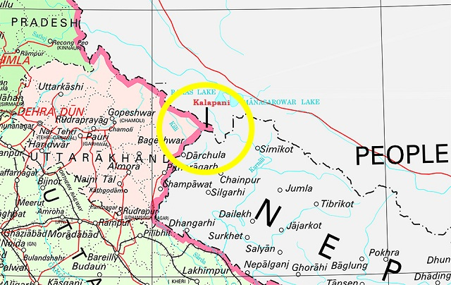
  • Mount Kailash is a 6,638 m (21,778 ft) high peak in the Kailash Range, which forms part of the Trans Himalaya in the Tibet Autonomous Region of China.
  • The Kailash Mansarovar Yatra is undertaken by two routes,
  1. Lipulekh Pass in Uttarakhand - This route passes through a very mountainous area.
  2. Nathu La Pass in Sikkim - This route opened a few years ago in Sikkim is fully motorable.
  • Defence Ministry inaugurated the Link Road to Kailash Mansarovar recently.
  • The link road connects Dharchula to Lipulekh, China Border which is known as Kailash-Mansarovar Yatra Route.
  • India’s plans to shorten the travel time for pilgrims to Kailash Mansarovar ran into a diplomatic trouble as Nepal strongly objected to the new link road from India to China.
  • Nepal’s Foreign Ministry said the decision to build the road through territory at the Lipulekh pass that it claims as its territory is a breach of an agreement reached between the two countries to discuss the matter.
  • This is due to the outstanding boundary issues” on Kalapani (where Lipulekh lies) and Susta.
  • Union Ministry of External Affairs said the road going through Uttarakhand’s Pithoragarh district “lies completely within the territory of India”.
  • The road that starts from Dharchula in Uttarakhand and runs 80 km to the Lipulekh pass was built by the Border Roads Organisation to help shorten the travel time to reach Kailash Mansarovar in Tibet by about three days each way.

Kalapani Issue

  • After the bifurcation of the state of Jammu and Kashmir (J&K) into the Union Territories of J&K and Ladakh, the Kalapani territory became the bone of contention between India and Nepal.
  • In the latest political map of India, India reiterated its claims on the region that Nepal considers its own territory in Darchula district.
  • According to India, the historic Kalapani region forms part of the state of Uttarakhand.
  • Kalapani is a valley that is administered by India as a part of the Pithoragarh district of Uttarakhand - It is situated on the Kailash Mansarovar route.
  • The Kali River in the Kalapani region demarcates the border between India and Nepal.
  • The Treaty of Sugauli signed by the Kingdom of Nepal and British India (after Anglo-Nepalese War) in 1816 located the Kali River as Nepal's western boundary with India.
  • The discrepancy in locating the source of the river led to boundary disputes between India and Nepal, with each country producing maps supporting their own claims.
  • In the recent map issued by the Indian government, the Pakistan-occupied Kashmir forms the part of the newly-created Union Territory of Jammu and Kashmir, while Gilgit-Baltistan is located in the Union Territory of Ladakh.


Susta Area

  • Susta area is one of the disputed territories between India (Uttar Pradesh) and Nepal.
  • Susta is located on the bank of the Gandak river (called Narayani river in Nepal).
  • The change of course by the Gandak River is the main reason for disputes in the Susta area.
  • The area is very fertile for agriculture because of the alluvial soil brought by the river.

Kali River

  • It is also known as Sharda river or Kali Ganga in Uttarakhand.
  • It joins Ghagra river in Uttar Pradesh, which is a tributary of Ganga.
  • River Projects: Tanakpur hydro-electric project, Chameliya hydro-electric project, Sharda Barrage.

Global mean surface temperature

  • In earth science, global surface temperature (GST) is calculated by averaging the temperature at the surface of the sea and air temperature over land.
  • In technical writing, scientists call long-term changes in GST global cooling or global warming.
  • Periods of both have happened regularly throughout earth's history.
  • Since the beginning of global temperatures in 1880 up to 1940, the average annual temperature has increased by 0.2 °C.
  • The temperature was then stable between 1940 and 1970.
  • And it has been increasing again since 1970 by 0.18 °C each decade.
  • The average global temperature has increased by 0.9 °C (1.5 °F) compared to the baseline temperature which is about 14 °C.
  • Although a pause has been observed between 1998 and 2013, the global warming continues since at the same pace as before.
  • According to recent reports last year was the seventh warmest since record-keeping commenced in 1901.
  • The annual mean surface air temperature, averaged over the country, was +0.36°C above average, the average is defined as the mean temperature from 1980-2010.
  • The highest warming observed over India was during 2016 or 0.71°C above the mean.
  • 2018, which was the sixth warmest, was 0.41°C, and 2017 was 0.55°C warmer, than the average.
  • According to the World Meteorological Organization, the rise in global mean surface temperature during 2019 (January to October) was +1.10°C.


Source: The Hindu

Login or Register to Post Comments
There are no reviews yet. Be the first one to review.

ARCHIVES

MONTH/YEARWISE ARCHIVES

Free UPSC Interview Guidance Programme